No products
Product successfully added to your shopping cart
There are 0 items in your cart. There is 1 item in your cart.
America the Beautiful
- Sets of coins
-
Coins
- Coins Russia and CIS
-
Europe
- EURO
- Austria
- England
- Belgium
- Germany
- Italy
- Spain
- Latvia
- Lithuania
- Estonia
- Luxembourg
- Portugal
- France
- Finland
- Cyprus
- Andorra
- Greece
- Netherlands
- Slovakia
- Slovenia
- Ukraine
- Belarus
- Sweden
- Poland
- Norway
- Denmark
- Ireland
- Iceland
- Switzerland
- Monaco
- Liechtenstein
- Bulgaria
- Hungary
- Moldova
- Romania
- Czech
- Vatican
- Albania
- Bosnia and Herzegovina
- Macedonia
- Malta
- San Marino
- Serbia
- Croatia
- Montenegro
- Turkey
- Kazakhstan
- Transnistria
- Scotland
- Gibraltar
- North America
- South America
- Australia and South Pacific
- Africa
- Asia
- Tokens
- Silver
- Accessories
- Sochi 2014
- Banknotes
- Sale
- Marriages and species
- Sundry
Top sellers
-

-

-

Official set of series Russian Federation. Issue 11
Official set of series "Russian Federation". Issue 11
4 650 руб -

100 RUB Sochi 2014
680 руб -

-

-

10 kopeck 2015 MMD
7 руб -

-

1 Dollar First Patent 2018
250 руб -

Official set of series Russian Federation. Issue 12
Official set of series "Russian Federation". Issue 11
5 350 руб
No supplier
Viewed products
 View larger
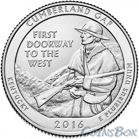
25 cents 2016 The 32nd Cumberland-Gap National Historic Park
Data sheet
| Depth | 1,7 |
| Weight | 5,67 |
| Diameter (mm) | 24,3 |
| Material | Copper-Nickel |
| Edge of the coin (milling) | fluted |
| Country | USA |
| Release date | 2016 |
| Quality | UNC |
More info
25 cents (quater) 2016 from the series National Parks - 32nd National Historical Park Cumberland-Gap Kentucky.
Obverse: In the center of the coin is a portrait of President George Washington to the left (shown in the restored version of the original portrait, used since 1932 on coin-kvarterah). Above the semicircular name of the issuing country: UNITED STATES OF AMERICA, in the semicircle the value of the coin is written - QUARTER DOLLAR. To the left of the portrait is minted the word LIBERTY (FREEDOM), on the right in a few lines - IN GOD WE TRUST (WE BELIEVE IN GOD) and the letter of the mint.
Reverse: in the center of the coin there is an image of a man with a gun in the background against the mountains, which looks to the left (to the west). To the left of the image is the inscription: "FIRST DOORWAY TO THE WEST" (the first way to the west). In the lower part of the coin there is an inscription: "KENTUKY / 2016 / E PLURIBUS UNIUM" (Kentucky / 2016 / as a whole). In the upper part of the coin is the inscription: "CUMBERLAND GAP" (Cumberland Gap).
The Cumberland Pass is a V-shaped depression on the Cumberland Plateau (part of the Appalachian Mountains) in eastern Kentucky. Its length is 42 km, width - from 1.5 to 6.5 km. Indians of the Cherokee and Shawnee long before the arrival of the Europeans used it as a kind of "gate" through the mountains. Through the Cumberland Pass passed an Indian trail, known as the Way of the Warrior. Coniferous and deciduous forests covering the slopes were not inhabited and used as hunting grounds.
The Europeans appeared here in 1750, it was Thomas Walker's reconnaissance expedition. Walker named the local river in honor of the Duke of Cumberland, son of the English King George II. Over time, this name spread to the whole region. Walker also composed the first description of the Cumberland gap, which, in his opinion, was to become the main artery for migration to western territories lying on the other side of the Appalachians.
Following Walker, many hunters moved to the area of the Cumberland Pass, and in 1755 the first European settlement was founded here, and six more villages appeared simultaneously with it. From that moment until 1783, the number of migrants increased from 300 to 12,000, seven years later, 73 677 people lived there, in the next decade the European population tripled. By 1800, out of 400,000 people who had moved to the west of America, three-quarters walked and rode across the Cumberland Pass, where a road was built, suitable for the passage of wagons.
During the Civil War, the Pass was of strategic importance, it was called "American Gibraltar".
In the 1880s. In these places the process of industrialization has unfolded. There were coal cuts, railways, factories ... In the early 1920's. The public began to talk about the need to preserve in its original form the beauty and natural wealth of the Cumberland Pass. To create the existing national park it took almost twenty years of discussions.
In the national park visitors can see caves (they are recorded here 24), waterfalls, a huge grove of rhododendrons,
Forests and rocks, the ruins of fortifications of the Civil War and traces of iron mining, the empty "ghostly" ancient village of Hensley and the Powell valley with picturesque farms located 610 m below the road.
59 species of rare plants grow on the park territory, many species of animals live, including the white-tailed deer, the black bear (baribal), the rabbit, the raccoon, the opossum, the gray squirrel, the fox, the wild turkey ...
Released: 4 April 2016.


